Course Maps & Descriptions
scroll to: course maps / decision point map / turn-by-turn descriptions
Course Maps
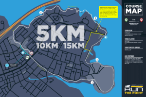
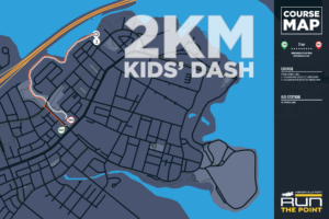
Click on a course map below to see the full size map in a pop-up window ... or follow the links below each map for different viewers.
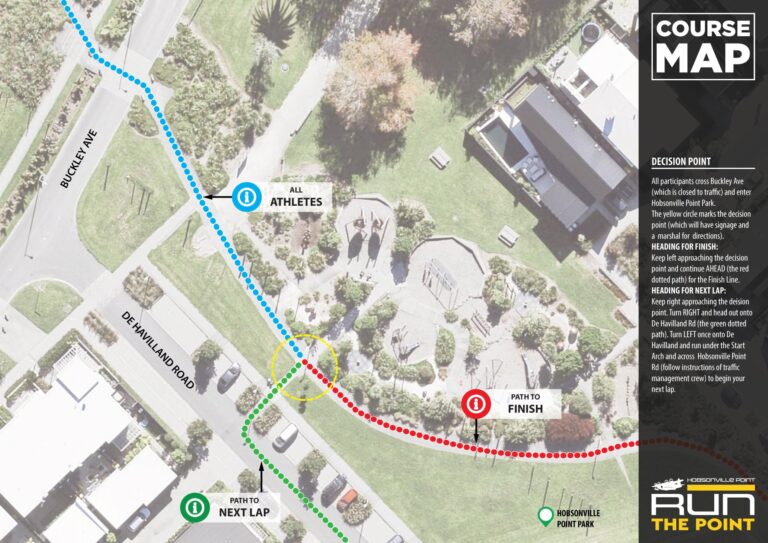
Decision Point Map
The "Decision Point" at Run the Point is the part of the course where particpants must choose to continue on to the finish line or branch off to begin another lap of the 5km course. You'll find it just after crossing Buckley Ave and entering Hobsonville Point Park. Check out the map here to see the exact location and procedure required.
For those in the 10k, you'll branch off at the end of lap one and carry on for the finish line at the end of lap two. For 15k runners, you'll branch off at the end of lap one and lap two ... and carry on towards the finish line at the end of lap three.
Turn-by-Turn Descriptions
Follow our detailed description of each course ...
5km Lap Turn-by-Turn
KM 0.0 | Start | De Havilland Drive
The race starts under the big arch of De Havilland Drive, bordered on one side by apartment blocks and on the other by a rising grass bank up to the main event venue, Hobsonville Point Park. This gives the start an "amphitheatre" feel and builds the excitement as we get ready to get the event underway. As the gun goes, runners pass under the start arch and continue across the junction with Hobsonville Point Rd.
Important! Hobsonville Point Rd is not closed to traffic. Traffic Management staff will stop all traffic on the main crossroads for the runners start at 8am and again for the walkers at 8:03am.
On the other side of the junction, continue on De Havilland Drive past Kanuka Rd and Clarke Rd on your right.
KM 0.3 | Bear Right > Te Ara Manawa / Hobsonville Coastal Walkway
Just past the junction with Joshua Calder Drive, runners will mount the southern (right side) pavement of De Havilland Dr. This pavement quickly bears away from the road to become to Te Ara Manawa / Hobsonville Coastal Walkway. Continue along the walkway and you will pass community allotments and The Rifle Range - an outdoor community theatre - on your left.
KM 1.1 | Turn Right > Coastal Track
Just beyond the 1km marker, the track arrives at a T-junction. A right turn here takes you onto the main coastal track, which is a combination of hard surface and gravel. Ignore the small detour on your right and continue along the track which does a 270 degree loop around the outside of Onekiritea Park.
KM 1.8 | Bear Right > Mangrove Shortcut
A modern concrete path branches off the main track to the right. This path is a shortcut through a mangrove section and you'll rejoin the main coastal path on the other side.
KM 1.9 | Turn Right > Coastal Track
At the end of the concrete path, turn right onto the main coastal track.
KM 2.0 | Bear Right > Forest Shortcut
Once again, the shortest path around the peninsula - and the one we want to follow - bears off to the right. This path is narrower and gravel and runs for a short distance between trees.
KM 2.1 | Turn Right > Coastal Track
At the end of the gravel shortcut, turn right back onto the main coastal track.
KM 2.3 | CONSTRUCTION DETOUR
Due to construction on the new Upper Waitematā Marine Centre, the coastal path near to Catalina Bay has been closed for our 2023 and 2024 events. Consequently, we will be following a detour for these events via Bomb Point Drive and Launch Rd. This detoure adds an additional 200m to the 5km course.
Turn Left > Footpath towards Bomb Point Drive
Turn Right > Bombo Point Drive footpath
Ahead > Entrance toBomb Point Drive public car park. CARE NEEDED!
Turn Right > Launch Rd
At the bottom of Launch Rd, you will rejoin the course at the point where the coastal track emerges onto the Launch Rd roundabout.
Important! KM marks below are based on the original course. Add 200m to account for the detour.
KM 2.6 | Ahead / Launch Rd Roundabout
Follow the footpath around the seaward side of the Launch Rd roundabout, which continues on to the harbour sea wall. Follow the sea wall towards the ferry jetty.
KM 2.9 | Turn Right & Left / Elevated Boardwalk
Just past the entrance to the ferry jetty on your right, take the footpath - with a sharp right and then left turn - to join the elevated boardwalk which passes in front of Fabric Cafe. Past the cafe, the elevated boardwalk rises above mangroves with wide views of the harbour and the Upper Harbour Bridge. The walkway makes several turns as it follows the coastline on a broadly left handed track.
KM 3.3 | Turn Left & Right / Rejoin Coastal Track
At the end of the elevated boardwalk, you'll turn hard left and then hard right on an upward switchback to rejoin the main coastal path.
KM 3.8 | Ahead / Bear Park
Take care as the footpath crosses a small park which also includes the Bear Park Early Childhood Centre. As the centre has a car park in it, the coastal path crosses the access road which should not have any vehicles on a Sunday morning, but care is still needed.
KM 4.8 | Ahead / Hobsonville Point Park
At the end of the Coastal Walkway, cross over Buckley Ave (closed to traffice) and enter Hobsonville Point Park
KM 4.82 | DECISION POINT
Shortly after crossing Buckley Ave and just inside the park, you'll reach the Lap/Finish Decision Point. Signage and marshals will direct you to KEEP RIGHT FOR NEXT LAP or KEEP LEFT FOR FINISH. Just ahead, there is a footpath on the right which leads out onto De Havvilland Road.
> For Next Lap:
If you are intending to continue on for your next lap, take this footpath and TURN LEFT on De Havilland Rd and run towards and under the Start Arch to begin your next lap.
> For Finish:
Continue on the main footpath through the park and follow the signs and fences into the finish chute.
Congratulations ... you made it!
Kids' Dash Turn-by-Turn
KM 0.0 | Start | De Havviland Rd
Race Start will be on the southern side of the start arch on De Havilland Rd. Kids will start in the opposite direction from the adults and will run *away* from Hobsonville Point Rd and towards Buckley Ave.
KM 0.2 | Turn Right / Buckley Ave THEN Turn Left / Coastal Walkway
At the end of De Havilland Rd, kids will turn right onto Buckley Ave for a few metres before turning left into the entrance of the coastal path. Keep in mind there will still be adults completing their own events so - please everyone - KEEP LEFT!
KM 1.0 | Turnaround / Semi-Circular Bridge
The kids turnaround point is almost exactly 1km from the start and finish lines and is right in the centre of one of two beautiful curving elevated footbridges on the Coastal Walkway (you already ran over the other one around 0.5k!).
KM 1.8 | Ahead / Hobsonville Point Park
Emerging from the Coastal Walkway, kids will follow the same route as the adults, crossing Buckley Ave and then taking the main footpath through Hobsonville Point Park all the way to the finish chute and finish line.
Congratulations ... you made it!


